South Island Road Trip New Zealand 2020
And We’re Off
July 27th – August 6th
 |
| The Southern Alps |
 |
| Liam at the helm of our trusty steed |
And so on July 27th we boarded our Air New Zealand flight and winged our way from our base in Whangarei to Christchurch on the south island arriving around 10am.
After completing the necessary paperwork at the Britz depot and a hands on tour of the van itself we were off. First stop the supermarket and then on to our pre-booked “Top 10” Holiday Park for two nights and a celebratory tipple of Champers. Our adventure was about to begin.
 |
| View from The Gondola |
We spent three days in Christchurch doing all the touristy things which included taking the city tram ride to see the sights, riding the Gondola 862m to the top of Mt Cavendish to take in the views of the southern Alps, the city landscape and the town of Lyttelton and its surrounds.
Sadly the fog rolled in as we reached the top of the cable car ride and a good hour later it was still as thick as pea soup. The best we could do was to wait a while longer and enjoy lunch and the exhibits that were on offer up there. The fog never did lift so down we went. It was a real shame as the views from up there would have been spectacular.
 |
| Stunning Architecture |
 |
| Botanical Gardens |
 |
| Queen Victoria Statue |
 |
| Riverside Centre |
The following day we took the very winding and steep road, Liam was not fussed on that road at all, out to the historic town of Akaroa on the Banks Peninsular some 80km from the city.
This cute little French influenced town sits on the side of the lake and is full of cafes and restaurants, renovated facades and nicky nakky tourist shops.
Having been settled by French pioneers way back it is French right down to the street names and heritage houses. From here it was another taxing 80km drive back to Christchurch after which Liam enjoyed a well earned couple of drinks!
 |
| French house Akaroa |
 |
| Akaroa Harbour |
 |
| Silo Accommodation |
 |
| Snowy Mts heading north |
So now that we’d settled into our RV and had provisioned up it was time to head north along SH1 on the east coast to our planned Department of Conservation (DOC) campsite at Marfells Beach near Cape Campbell. And what a great setting. The campground was right alongside the beach and had all the amenities we needed, showers, loos, picnic tables and BBQs all for just $8 pp. It was a steal.
 |
| Friendly workers along the way |
 |
| Marfells Beach Beach Campsite |
 |
| Sunrise |
As we soon found out some DOC campgrounds have a host person while other more remote sites run on an honesty system where you put your fees in the envelope supplied and into the money box . These campgrounds are scattered all over both the north and south islands and being the time of year we were travelling there was no need to make a reservation.
A little further north is the town of Blenheim, the gateway to NZ’s famouus Marlborough Wine Region. Here we caught up with cruising friends Brenda and David who we’ve know since our time in the Mediterranean. They still have there boat Bandit but our now land lubbers and Vintners running Whitehaven Vineyard. We had a lovely evening with them reminiscing on times gone by. Whilst in the area we also popped into the Cloudy Bay cellar door and saw two of our other favorite vineyards, Matua and Stoneleigh.
 |
| Dinner with Brenda & David |
 |
| The Barrel says it all |
 |
| View over Picton |
Leaving Blenheim behind we had a pit stop in Picton then it was on to the picturesque Queen Charlotte Drive around the Marlborough sounds and through to Nelson for a replacement house battery as the current one was in its death throws. We were now heading across the top of the south island and on to the west coast, stopping overnight for free camping along side the Buller River and taking in the Swing Bridge across the Buller George the next morning.  |
| Swing Bridge over Buller Gorge |
The bridge is the longest swing bridge in New Zealand and spans the river at 110m and is suspended 20m above the rushing waters below.
Liam has a fear of heights so he sat this one out while I toddled over the wire swing bridge which really does swing and along the the Faultline loop walk, taking in geological and historical sites dotted throughout the heritage park, including Whites Creek Faultline which was the epicentre of the 1929 Murchison earthquake where the ground rose 4.5 m. It was nice to get out of our van and stretch the old legs I must say.
 |
| Skinny blind corners |
 |
| One lane bridges were everywhere |
Moving further west we had a squiz at the township of Westport but decided to push on down the scenic coast road SH16 to Pancake Rocks in the Paparoa National Park. This entire stretch of coast is just vista after vista, bend after bend. Pancake Rocks rates very high on the tourist attraction ladder and to put it simply it’s weathered layer upon layer of compressed limestone rock, known as stylobedding, which is continuously pounded by the unrelating Tasman Sea. And yes as the name suggests these rocks really do look like stacks of pancakes.
 |
| Beautiful but rugged coastline |
It’s a wild place on a very inhospitable coastline complete with massive surging blowholes and you really do get a sense that Mother Nature does indeed rule the roost here.
 |
| Pancake Rocks |
 |
| Blowholes |
Next up on our agenda was the coastal town of Greymouth some 46 klms further south. This is the largest town on the entire west coast sprouting all the major supermarket chains, petrol stations and everything else that the smaller towns lack. It’s more of a pass through destination rather than a destination itself. Mind you it is the end of the line for the 223klm Tranz Alpine rail journey which begins over on the east coast in the city of Christchurch. It is rated as one of the world’s greatest train journeys.
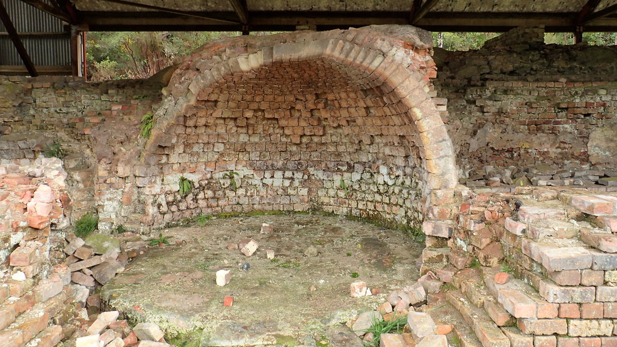
Having done some provisioning and refueling we headed a few K’s out of town to Brunnerton the site of the Brunner Coal Mine.
Back in March1896 an explosion ripped through the mine killing 65 men working there, almost half of the underground workforce. The cause some said was determined to be a charge that was let off in part of the mine where no one was supposed to be working but many miners not involved in the explosion said that it was Fire Damp, methane gas which forms when decaying plant material turns into coal which then becomes explosive when mixed with a certain amount of oxygen.
 |
| Brunner Mine |
 |
| At the mine |
There was no damage to the above ground buildings at the site as the explosion was so deep inside the mine itself. When the rescue crews arrived they found that railway line and trucks were twisted and smashed.
 |
| The brick kiln |
The explosion was huge and some bodies could only be identified by their clothing The Brunner Mine disaster was the deadliest mining disaster in New Zealand’s history. The mine closed in 1906, however there are still a few structures at the site including the coke ovens have been preserved at the historic site.
Rather than rush off down the coast road again we decided to spend the night in Greymouth. The council have a freedom camping park right on the shores of the beach and so far this little spot tucked away for those in the know was yet another winner. Thankyou Greymouth council.
Hokitika would be our next stop. The cute seaside town is well known for it”s three day driftwood arts festival during January and for its beautiful buildings built during the gold rush era of the 1860’s.
 |
| The main street |
After a lazy wonder through the streets and a bite of lunch down at the beach it was time to find a spot for the night.
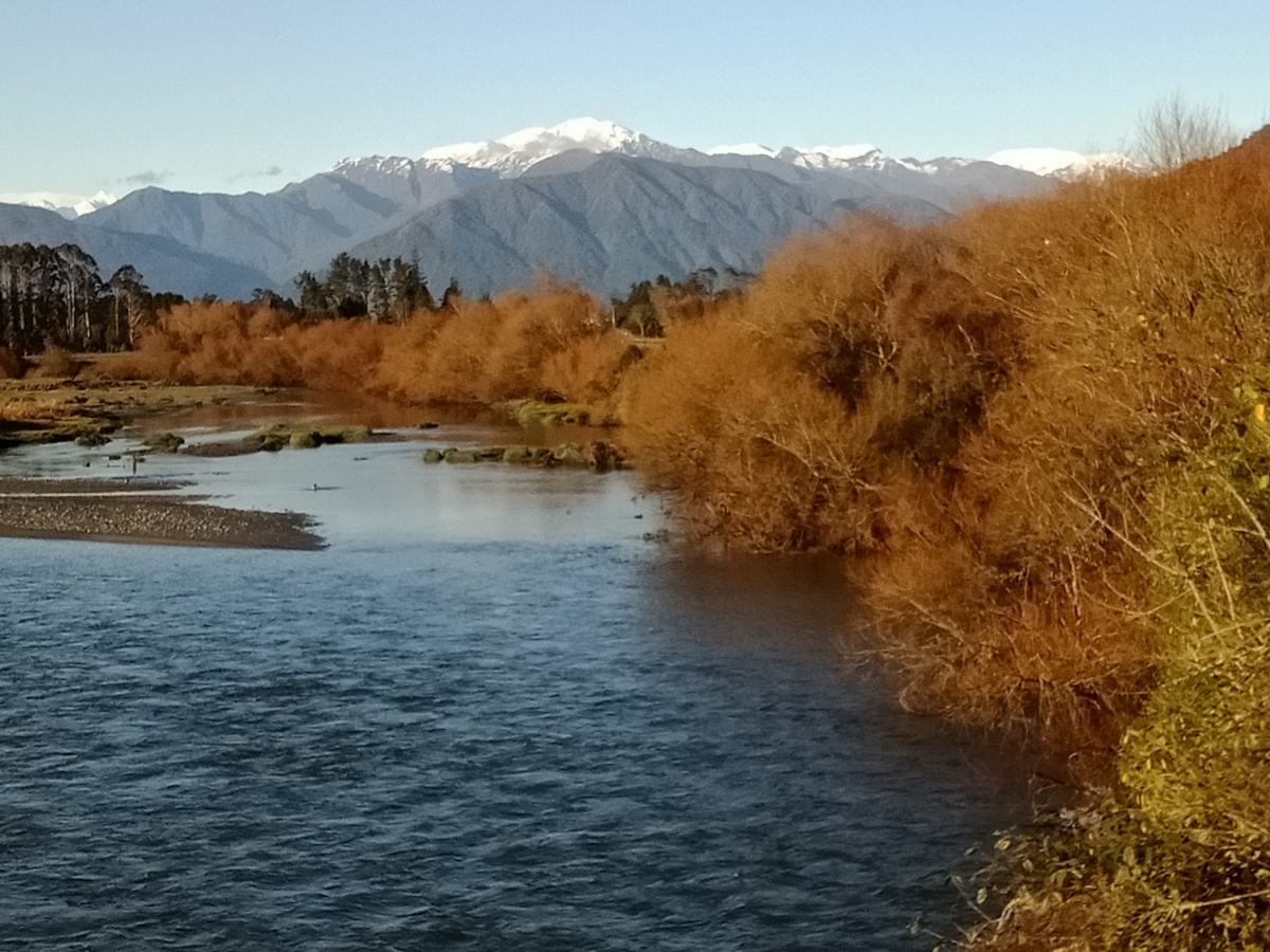
As the town has a strict no overnight camping rule we headed 10kls south to the DOC campground at beautiful Lake Mahinapua.
We settled in just metres from the waters edge and gazed across the lake to the snow covered alps in the distance. Such a tranquil setting and we had it all to ourselves.
 |
| Camping at the waters edge |
Up early next morning we were off to visit the West Coast Treetop Walkway.
We booked our tickets via the Grab One site which offers discounted tickets to many tourist attractions throughout NZ. We saved $12 on each ticket using this site.
The walkway opened in Dec 2012 having taken just five months to complete. Built in Australia then shipped to the west coast it was assembled using cranes and 13,500 bolts and took just six weeks to put the massive structure together. It was designed by the same engineer and architect team who built four similar structures in Australia. The walkway meanders through the treetops at a height of 20 mtr above ground, its a very enjoyable stroll which took us about 45 mins from go to wow.
The birdlife and lookouts had fabulous views but the best was from the top of the 40 metre observation tower. Needless to say Liam didn’t venture up it with me.
 |
| Looking down from 40 metres |
 |
| Liam happier down here |
From here we drove out 33klms to the Hokitika gorge but on the way out the heavens opened and by the time we got to the carpark it was torrential. We sat for an hour and then abandoned our plans and headed to our campground at Hans Bay–Lake Kaniere for the night. We’d try for the gorge again tomorrow.
 |
| Above and below on the way to the Gorge |
 |
| Cows ambling across the road |
The morning brought clear skies with a backdrop of snowy alps. We packed up the van and headed back out to the gorge and this time the gods must have been smiling on us.
 |
| What a view to wake up to |
 |
| Mt Cook in the distance |
Half a million years of glacial movement has carved out this porcelain white ravine and hues of turquoise water sparkled in the sunlight.
 |
| Bridge over the gorge |
 |
| The aqua waters of Hokitika Gorge |
It didn't take long to take in the sights and we were soon back on the road to Hokitika for a late breakfast and then on to famed Arthurs Pass.
So stayed tuned for the next installment of our South Island road trip.
**********************************************


No comments:
Post a Comment